Perry-Castañeda Library
Map Collection
Spain Maps
The following maps were produced by the U.S. Central Intelligence Agency, unless otherwise indicated.
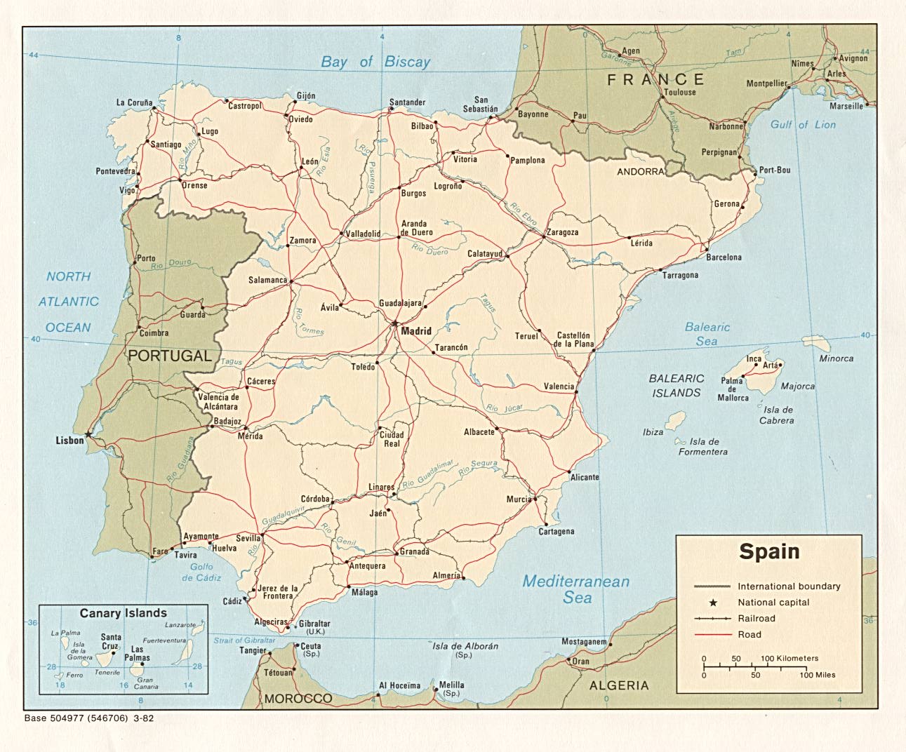
Country Maps- Spain (Political) 1982 (220K) and pdf format (227K)
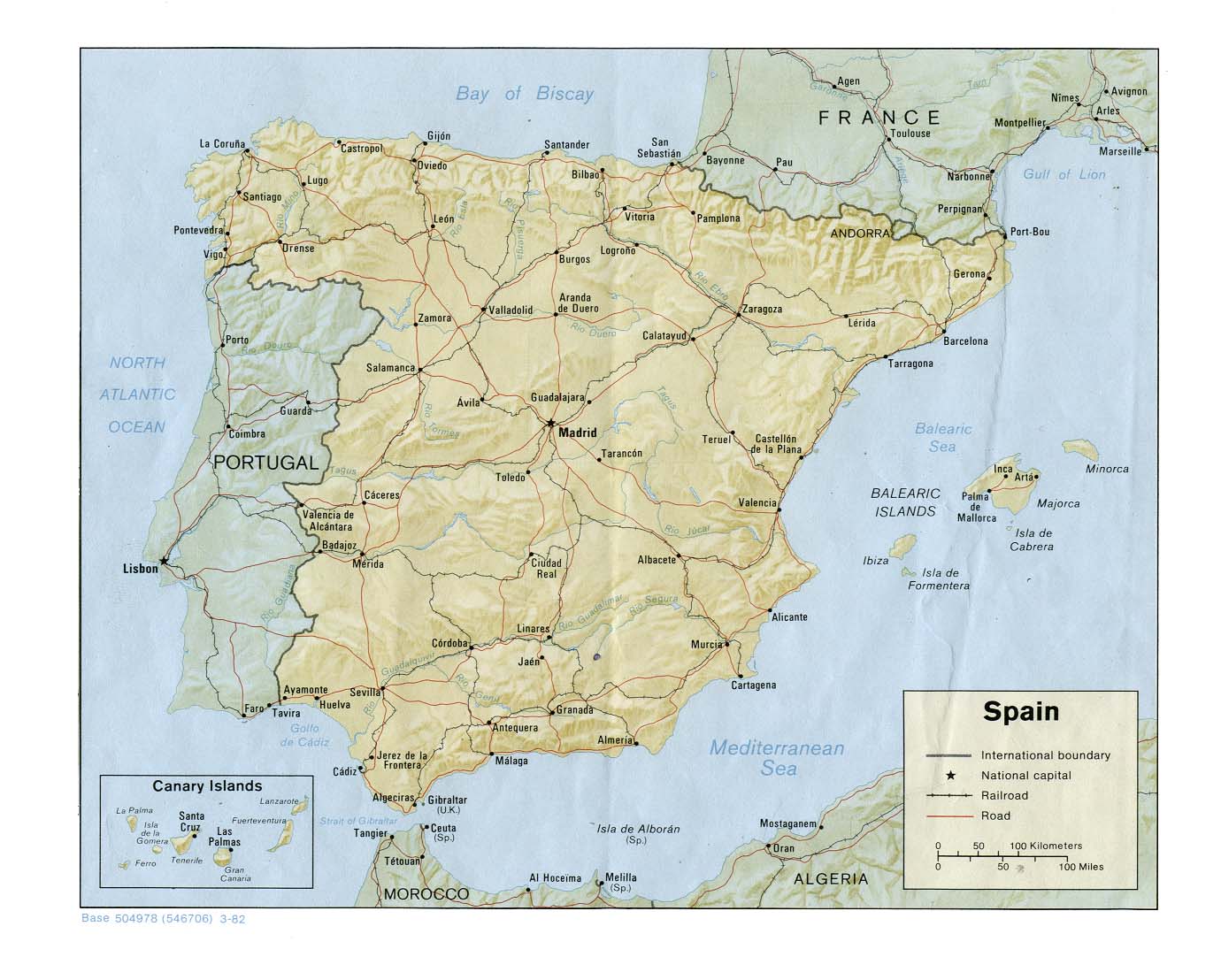
- Spain (Shaded Relief) 1982 (265K) and pdf format (188K)
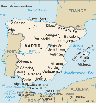
- Spain (Small Map) 2016 (25.3K)
- Alicante U.S. Naval Forces Europe 1999 (45K)
- Barcelona U.S. Naval Forces Europe 1999 (45K)
- Benidorm U.S. Naval Forces Europe 1999 (45K)
- Malaga U.S. Naval Forces Europe 1999 (45K)
- Palma U.S. Naval Forces Europe 1999 (45K)
- Rota U.S. Naval Forces Europe 1999 (45K)
- Hispania [Ancient Spain] (612K)
- From A Classical Atlas of Ancient Geography by Alexander G. Findlay. New York: Harper and Brothers 1849.
- Spanish Kingdoms Circa 980 A.D. - 1556 A.D. (8 Maps)
- From the Atlas to Freeman's Historical Geography, Edited by J.B. Bury, Longmans Green and Co. Third Edition 1903.
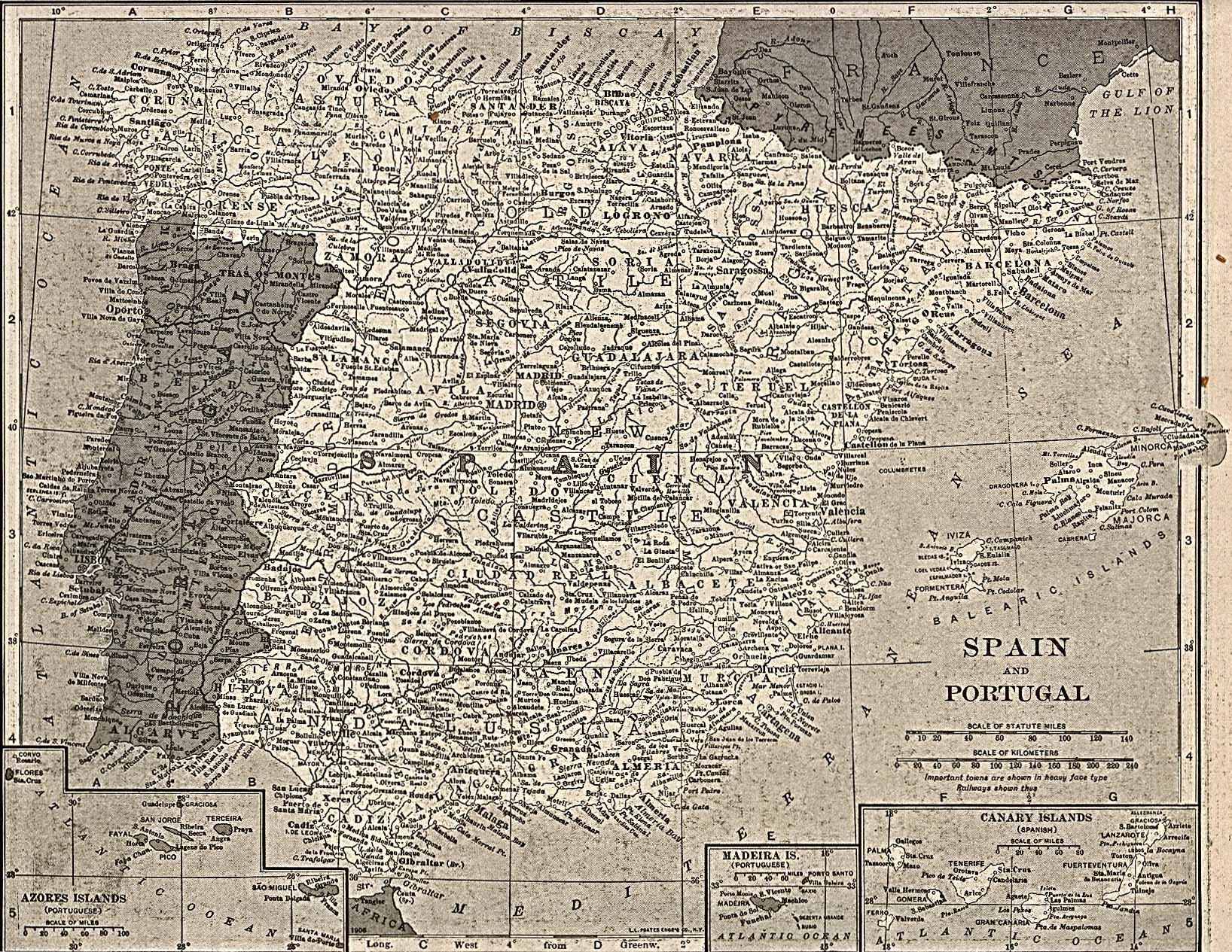
- Spain and Portugal 1917 (855K)
- From The New Encyclopedic Atlas & Gazetteer of the World, Edited & Revised by Frances J. Reynolds.
- Spain City Plans 1943 U.S. Army Map Service
- From A Classical Atlas of Ancient Geography by Alexander G. Findlay. New York: Harper and Brothers 1849.
![Hispania [Ancient Spain]](historical/ancient_hispania_1849.jpg)
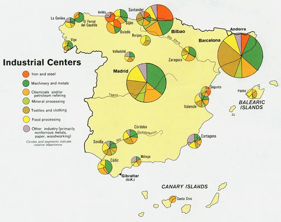
- Spain - Industrial Centers from Map No. 501745 1974 (134K)
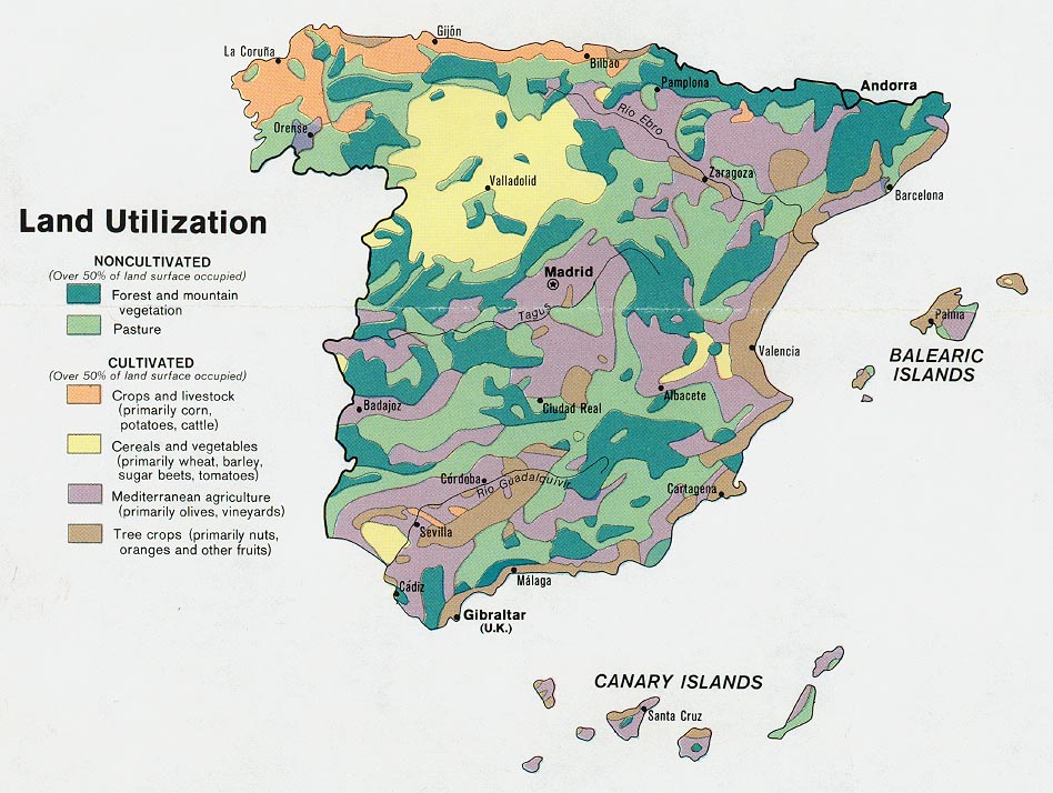
- Spain - Land Utilization from Map No. 501745 1974 (174K)
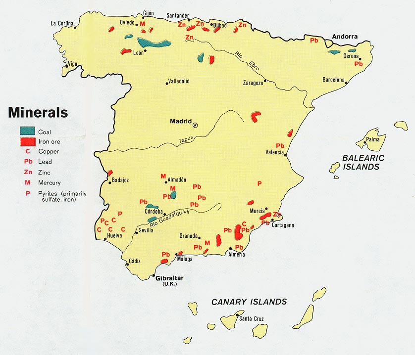
- Spain - Minerals from Map No. 501745 1974 (115K)
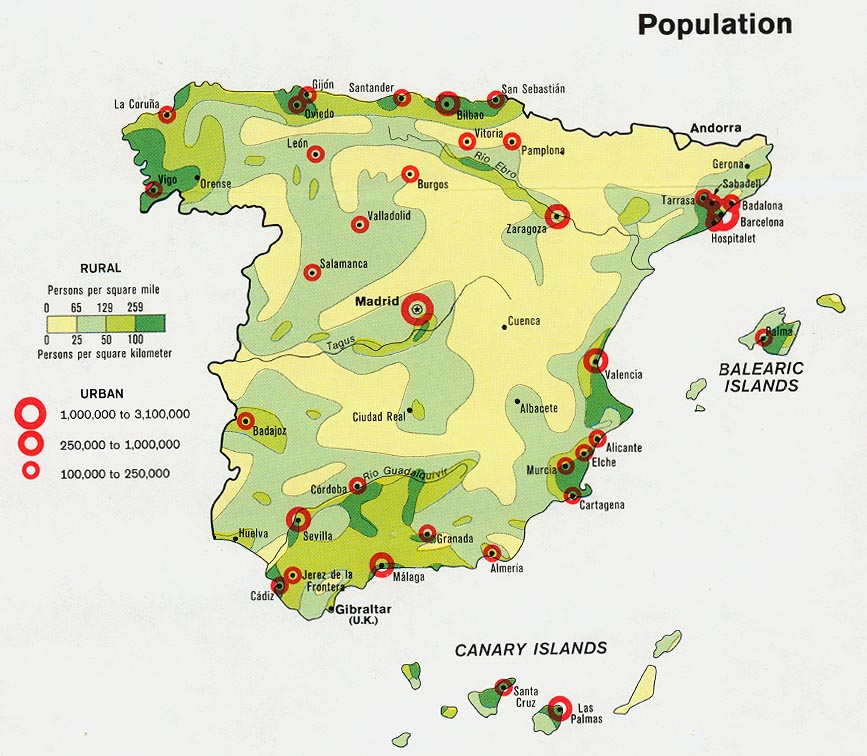
- Spain - Population from Map No. 501745 1974 (146K)
- 1:2,000,000 - Europe Series 4464, Great Britain War Office, 1965
- This series covers Spain
- 1:1,000,000 - International Map of the World
- This series covers Catalonia on sheet NK-31 and the Balearic Islands on sheet NJ-31 Clickable map
- 1:1,000,000 - Operational Navigation Charts Series U.S. Defense Mapping Agency Aerospace Center Not for navigational use
- This series covers Spain on sheets F-1 and G-1
- 1:500,000 - Europe Road Maps for Allied Forces Series M406 (GSGS 4798), Great Britain War Office, 1942-
- This series covers Spain
- 1:500,000 - Europe Series M404 (4072), Great Britain War Office, 1942-
- This series covers all of Spain
- 1:500,000 - Europe Series M406 (4798), Great Britain War Office, 1942-
- This series covers northern and eastern Spain
- 1:500,000 - Tactical Pilotage Charts U.S. National Imagery and Mapping Agency. Not for navigational use
- This series covers Spain
- 1:500,000 - World Series 1404, Great Britain. War Office and Air Ministry. 1958-
- This series covers parts of Spain
- 1:400,000 Spain and Portugal Road Map Series M481, 1:400,000, U.S. Army Map Service, 1943-
- This series covers all of mainland Spain
- 1:100,000 Canary Islands Series 4120, U.S. Army Map Service, 1943
- 1:400,000 Canary Islands Series 4306, U.S. Army Map Service, 1943
- 1:100,000 Spain Series 4109, 1:100,000, Great Britain War Office, 1941-
- This series covers the extreme southern tip of Spain
- 1:50,000 - Balearic Islands Series M788, U.S. Army Map Service, 1943
- This series covers all of the Balearic Islands
- 1:50,000 - Spain Series M781 and 787, U.S. Army Map Service, 1943
- These series cover large parts of southern and eastern Spain
- This series covers Spain
Maps on Other Web Sites