Perry-Castañeda Library
Map Collection
Haiti Maps
The following maps were produced by the U.S. Central Intelligence Agency, unless otherwise indicated.
Country Maps- Haiti (Political) 1999 (451K) and pdf format (331K)
- Haiti (Political) 1987 (164K) and pdf format (170K)
- Haiti (Shaded Relief) 1999 (451K) and pdf format (319K)
- Haiti (Small Map) 2016 (14.0K)
- Aquin original scale 1:10,000, Edition 1-DMA, Series E935, U.S. Defense Mapping Agency, 1988 (4.1MB) and PDF version
- Cap-Haitien original scale 1:12,500, Edition 3-DMA, Series E935. U.S. Defense Mapping Agency, 1994 (5.6MB) and PDF version
- Cayes 1:5,000 1987 (6.5MB)
- Fort Liberte original scale 1:12,500, Edition 3-DMA, Series E935. U.S. Defense Mapping Agency, 1987 (4.6MB)
- Gonaives original scale 1:12,500, Edition 3-DMA, Series E935. U.S. Defense Mapping Agency, 1993 (4.3MB) and PDF version
- Hinche original scale 1:10,000, Edition 1-DMA, Series E935. U.S. Defense Mapping Agency, 1988 (2.6MB) and PDF version
- Jacmel original scale 1:12,500, Edition 2-DMA, Series E935. U.S. Defense Mapping Agency, 1987 (5.2MB) and PDF version
- Jeremie original scale 1:12,500, Edition 2-DMA, Series E935. U.S. Defense Mapping Agency, 1987 (5.4MB) and PDF version
- Miragoane original scale 1:12,500, Edition 2-DMA, Series E935. U.S. Defense Mapping Agency, 1987, reprinted 2005. [PDF]
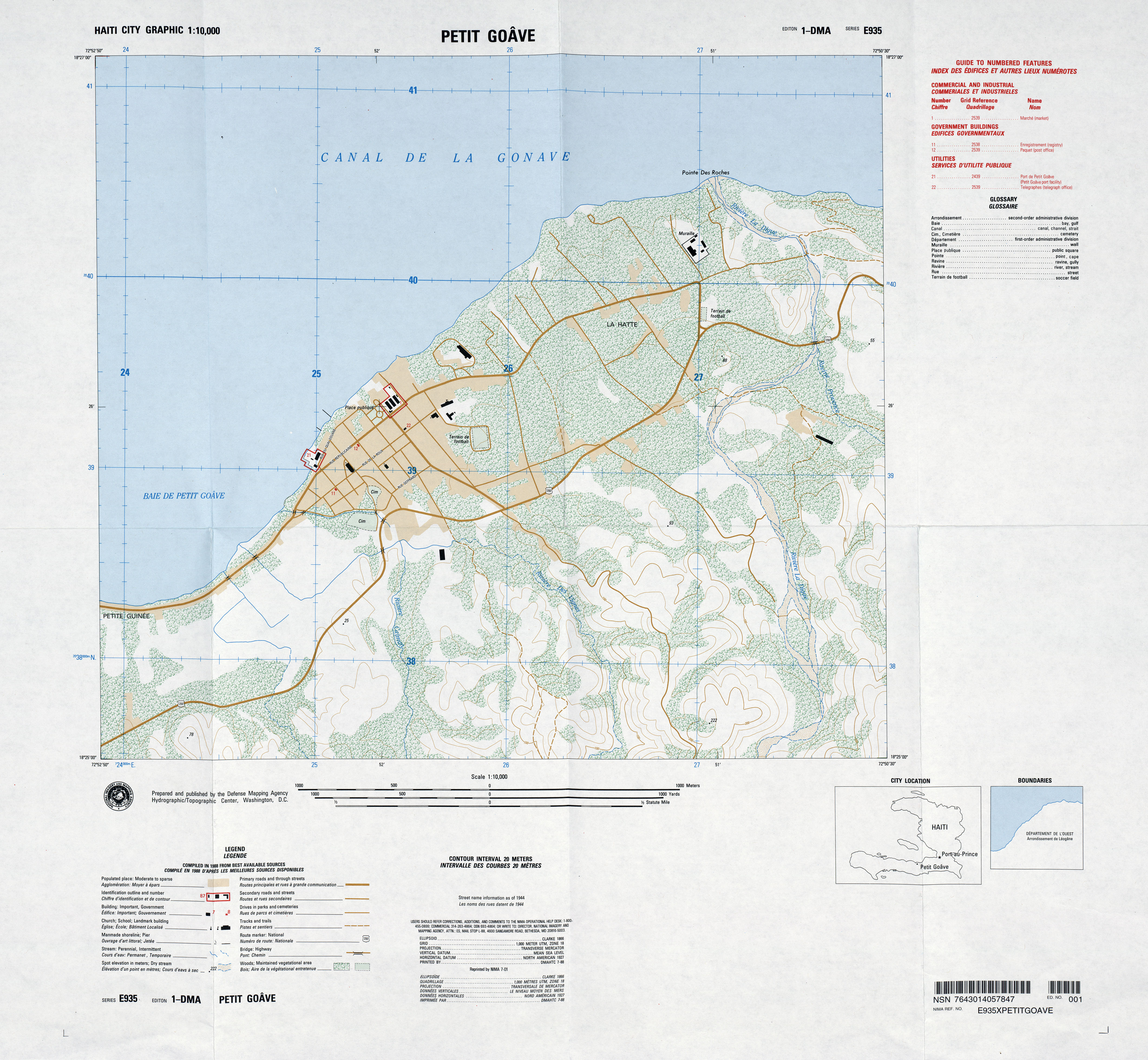
- Petit Goave original scale 1:10,000, Edition 1-DMA, Series E935. U.S. Defense Mapping Agency, 1988 (3.7MB) and PDF version
- Port-au-Prince, Sheet 1 1:12,500 1994 [small] (6.7MB)
- Port-au-Prince, Sheet 1 1:12,500, Edition 4-DMA, Series E935. U.S. Defense Mapping Agency, 1994 (18MB) and PDF version
- Port-au-Prince, Sheet 2 1:12,500, Edition 4-DMA, Series E935. U.S. Defense Mapping Agency, 1994 [small] (10MB)
- Port-au-Prince, Sheet 2 1:12,500, Edition 4-DMA, Series E935. U.S. Defense Mapping Agency, 1994 (28MB) and PDF version
- Port-au-Prince, Sheet 3 1:12,500, Edition 4-DMA, Series E935. U.S. Defense Mapping Agency, 1994 (8.8MB) and PDF version
- Port-au-Prince, Sheet 4 1:12,500, Edition 4-DMA, Series E935. U.S. Defense Mapping Agency, 1994 (12MB) and PDF version
- Port-au-Prince Image Base Map - Sheet 1 2010 [PDF]
- Port-au-Prince Image Base Map - Sheet 2 2010 [PDF]
- Port-au-Prince and Vicinity 1:12,500 U.S. Army Map Service 1967 (24.4 MB)
- Port-au-Prince - Central (orthophoto) 1:12,500 U.S. Army Map Service 1967 (629K) detail from Port-au-Prince and Vicinity
- Port-au-Prince - Mais Gate Airport (orthophoto) 1:12,500 U.S. Army Map Service 1967 (323K) detail from Port-au-Prince and Vicinity. A new map of this area is available through ReliefWeb
- Port-au-Prince - North (orthophoto) 1:12,500 U.S. Army Map Service 1967 (569K) detail from Port-au-Prince and Vicinity. Note: Airport on this map no longer exists.
- Port de Paix original scale 1:12,500, Edition 2-DMA, Series E935. U.S. Defense Mapping Agency, 1987 (4.8MB) and PDF version
- Saint-Marc original scale 1:12,500, Edition 2-DMA, Series E935. U.S. Defense Mapping Agency, 1987 (5.1MB) and PDF version
Detailed Maps
- Haiti - 1:1,000,000 (Central and East) (aeronautical chart) Operational Navigation Chart ONC J-27, 1:1,000,000, U.S. Defense Mapping Agency, Edition 8, 1988. Includes most of Haiti (central and eastern), all of Antigua and Barbuda, Dominican Republic, Puerto Rico, Saint Christopher and Nevis, Virgin Islands, and part of Greater and Lesser Antilles. [PDF]
- Haiti - 1:1,000,000 (West) (aeronautical chart) Operational Navigation Chart J-26, 1:1,000,000, U.S. National Imagery and Mapping Agency, Edition 11, 1998. Includes far western Haiti, all of Cuba, Jamaica, Navassa Island, and part of southern Bahamas. [PDF]
- 1:500,000 - Tactical Pilotage Charts U.S. National Imagery and Mapping Agency. Not for navigational use
- This series covers Haiti
- Haiti - 1:250,000 (aeronautical charts) Joint Operations Graphic (Air), U.S. National Geospatial-Intelligence Agency. Series 1501 [5 sheets with clickable index map].
- Haiti - 1:250,000 (aeronautical charts) Joint Operations Graphic (Ground), U.S. Army Topographic Command. Series 1501 [5 sheets with clickable index map].
- Haiti - 1:50,000 (topographic) National Geospatial-Intelligence Agency. The GeoPDF files can be viewed either as a regular PDF or by downloading the software when opening a file. Clickable Index Map for this series.
- Cap-Haïtien - 1:250,000 (topographic) U.S.G.S. 1984 (544K)
- Ile de la Tortue - 1:250,000 (topographic) U.S.G.S. 1984 (233K)
- Port-au-Prince - 1:250,000 (topographic) U.S.G.S. 1984 (612K)
- Southwest Haiti Overview National Geospatial-Intelligence Agency, January 2010 [PDF]
- This series covers Haiti
Thematic Maps
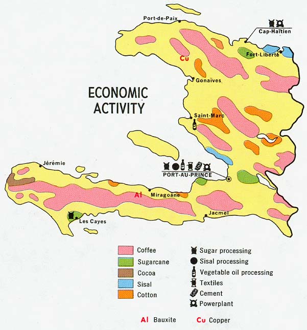
- Haiti - Economic Activity from Map No. 77972 1970 (90K)
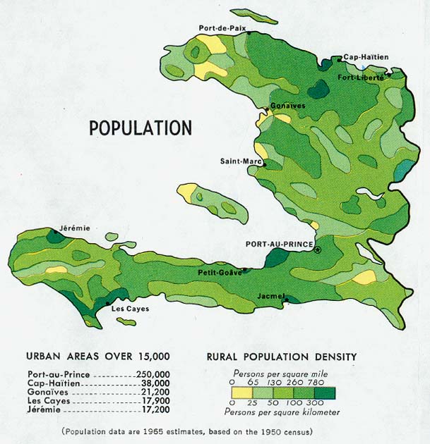
- Haiti - Population from Map No. 77972 1970 (96K)
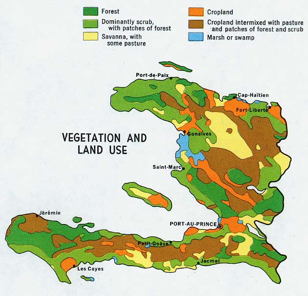
- Haiti - Vegetation and Land Use from Map No. 77972 1970 (102K)
Maps on Other Web Sites